Is A Living Shoreline Right For Me?
For contractors and residents considering the installation of a living shoreline, understanding the existing conditions of the site is critical. This information will help to identify the living shorelines techniques most appropriate for your site and increase the likelihood of success.
Visit The Nature Conservancy’s Living Shoreline Explorer App and type in your address. This site provides users with a preliminary look at specific site conditions that are important to consider when determining if a site is suitable for a living shoreline, including wind wave energy, boat wake energy, and maximum fetch. You can also view nearby existing living shorelines, shoreline erosion rates, and oyster and marsh habitat.
-
General Site Considerations
Note the following site specifics.
- Identify property boundary (refer to County tax maps for this information if necessary).
- Note existing erosion control structures such as rip rap or bulkheads present on site and on adjacent properties.
- Determine if the site is located within a designated shellfish harvesting area. View Map of the South Carolina Recreational Shellfish Management Areas or visit the TNC app.
- Note if the site is located on a designated navigational channel such as the Intracoastal Waterway.
-
Site Access
Determine how materials will be transported to the site. Select a path that impacts the least amount of existing salt marsh and estuarine habitat. Access from the water is often preferable to limit foot traffic and trampling in the critical area. Identify nearby access points that may include boat ramps, docks, and adjacent properties.
-
Sediment Firmness and Composition
Is your property lined by hard sand or soft mud? Assessing the firmness of sediment and sediment type will aid in deciding whether a living shoreline is an appropriate solution. If the sediment is too soft the materials may sink or slide. Additional design considerations can mitigate sediment softness such as placing wooden pallets underneath shell bags.
-
Potential for Erosion
Determine site conditions to better understand the cause(s) for shoreline erosion. Understanding the cause will better inform the living shoreline design. Refer to the TNC app which classifies estuarine shoreline energy associated with wind waves, boat wake, and fetch.
- Waterbody width: Approximate the width of the adjacent tidal creek/river. The wider the waterbody, the greater the wind and wave energy, which will increase the potential for erosion. Smaller tidal creeks may also experience erosion due to excess stormwater runoff or other factors.
- Boat traffic: Note boat traffic intensity in the waterway of focus.
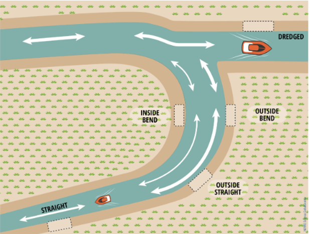
- Channel Shape: The ebbs and flows of the daily tidal cycle create a constant current in salt marsh waterways. These complex currents contribute to erosion but also deliver the suspended sediments that help build salt marsh habitat. Due to a combination of boat wakes and tidal currents, sites located on the outside bends of waterways are likely to have higher levels of energy compared to sites on inside bends.
Potential land-based and environmental stressors can impact your local salt marsh and lead to salt marsh decline. To learn how to determine if these stressors are present, visit Life Along the Salt Marsh: Troubleshooting Salt Marsh Decline.
The wave and current energy at a site highly affects the living shoreline approach (SCDNR, 2019).
-
Shoreline Width and Slope
Does the shoreline have a steep or gradual slope? Bank slope and width should be considered when selecting an appropriate living shoreline approach (Figure 1.4). Unless properly stabilized, a highly sloped shoreline can result in the living shoreline materials sliding down toward the water. Bank width is also important in determining where to place the materials. An escarpment is the erosional area of shoreline that has some degree of vertical drop off typically at the marsh edge. This is the area of shoreline that needs stabilization using a living shoreline or other approach. The escarpment may be uniform across the entire property or it may vary along the length of the shoreline. An escarpment generally means that the marsh is experiencing erosion which may be related to the overall energy in the area. The height of the escarpment greatly affects the viability and success of a living shoreline.
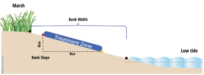
The bank slope and width should be considered when choosing a living shoreline (SCDNR, 2019).
The bank width, defined here as the average distance between the edge of the marsh and the water at low tide, should be wide enough to contain the proposed living shoreline. This is usually not an issue except at sites with steeply sloping banks. Recent research suggests that, regardless of bank width, living shorelines perform best at protecting marsh vegetation when installed relatively close to the edge of the existing marsh. Steep slopes may present problems for living shoreline materials. Living shorelines installed on very steep banks are at risk of sliding down-slope, potentially decreasing their effectiveness. The risk of sliding is greater at steep sites that also have very soft substrates.
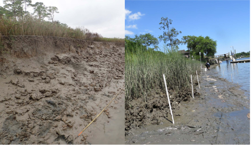
A view of a marsh with a pronounced escarpment on the Kiawah River (left) and without a pronounced escarpment on Hobcaw Creek (right) (SCDNR, 2019).
-
Salinity
Salinity is measured in parts per thousand (ppt). Freshwater has a salinity of 0 ppt whereas open ocean is approximately 36 ppt. In the South Carolina salt marsh and tidal creek system, salinity will vary based on proximity to the ocean, stage in the tidal cycle, and recent rainfall. Scan the area to determine if oysters are present in the vicinity. If you note oysters present, then oyster-based living shoreline methods are appropriate. If you cannot determine if oysters are present, determine the salinity at your site with the use of a refractometer. A simple refractometer should suffice and can be purchased at a pet supply store (used in saltwater fish tanks) or online. Based on SCDNR’s research, sites with low salinity, defined as an average of less than 15ppt, are not suitable for oyster-based applications for living shorelines.
-
Existing Habitat
Vegetation: Identify existing vegetation present in the salt marsh. A South Carolina salt marsh is typically dominated by a monoculture of Sporobolus alterniflorus, referred to as Spartina (in reference to the previous scientific name Spartina alterniflora), or Smooth Cordgrass. This plant is one of a few that can withstand the dynamic conditions created by the twice-daily ebb and flow of the tides. Another dominant plant in the salt marsh is Juncus romarieanus (Black Needlerush). Needlerush occurs in areas that receive less saltwater inundation due to a slightly higher elevation, a further distance from a creek bed, or located further upstream at a greater distance from the ocean. Utilize the previously mentioned TNC app to explore nearby habitats including marsh, tidal flats, and oyster reef.
Oysters: Are oysters growing nearby? Salinity can vary based on the water-path distance to the ocean and the quantity of freshwater inputs. Oyster-based living shorelines should only be considered at sites that rarely experience a salinity lower than approximately 15 ppt.
Reference Guide to the Salt Marshes and Tidal Creeks of the Southeastern United States for additional information on common plants and animals found along estuarine shorelines.
